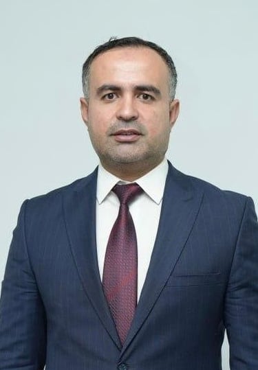
Dr. Rebar Tahseen Ali
PHD, Remote sensing and GIS in Geo-environment (climate change) Expert
Education
PhD in Remote sensing and GIS in Geo-environment (climate change)
College of science, Salahaddin University-Erbil, Iraq
2019 – 2022Master of Science in Remote sensing and GIS
College of science, Salahaddin University-Erbil, Kurdistan Region, Iraq
2012 - 2014Postgraduate Diploma in Geoinformation Science and Earth Observation, Stream: Earth Resource Exploration, ITC International Institute for Geoinformation Science and Erath Observation
Enschede, the Netherlands
2008 – 2009Bachelor of Science in Geology
College of science, Salahaddin University-Erbil, Kurdistan Region, Iraq
2001 – 2005
Professional Experience
Served as an expert for the Sustainable Development through improved Local Governance (SDLG) program in VNG International organization.
Working with Rwanaga foundation as a Judge in Youth Volunteers Initiative projects for 2023. The framework was environment sector and particularly climate change. Overall, 300 projects have been applied in all Iraq. Accordingly, the top ten projects have been selected based on international standards.
Working with local companies for environmental studies including Environmental Impact Assessment (EIA), Geo-planning, water treatment, waste management, GPS tracking system, and air pollution.
Working with IOM consultancy team in Iraq to map the land degradation, desertification, drought, and flooding in some selected areas.
Participating many workshops and seminars with private sector and governmental sector related to climate change, waste management, and environmental issues in Kurdistan region and Iraq.
Working as a freelance environmental consultant to prepare digital maps, reports, proposal for different environmental projects.
Peer Reviewer in many journals; Iraqi Geological Journal, Springer Nature, Journal of Applied Science and Technology Trends, and etc.
Training Courses and Workshops
Geoscience Summer School with University of Freiberg (Gocad software training, 3D Geological modeling, environment disaster management, and Mineral exploration), held between July 29 – August 1, 2014, in Freiberg. Awarded certificate of participation.
GIS day workshop in Erbil, held between November 29 – November 30, 2010, sponsored by Kurdistan Region Government, ESRI Lebanon, and Khatib & Alami.
Geoscience Summer School with University of Freiberg, held between July 20 – August 4, 2010, in Sulaimani. Awarded Certificate equal to 4 ECTS.
An intensive course from April 7 – September 5, 2008, ITC International Institute for Geo-Information Science and Earth Observation, Enschede, the Netherlands. Awarded Certificate equal to 25 ECTS. Which includes these topics:
1. Introduction to GIS and Remote Sensing.
2. Environmental Impact Assessment (EIA) and Strategic Environmental Assessment (SEA), using Spatial Decision Support tools.
3. Participatory GIS.
4. Natural Recourses and mapping.
Scientific workshop for opening M.Sc. joining program between Germany and Iraqi universities, held on 14 – 20,12,2009 in Germany.
Conferences
7th International Conference on Applied Science, Energy and Environment, held between January 28 – 30, 2025 in Tishk International University and Salahaddin University Erbil.
6th International Geological conference of Kurdistan (Geokurdistan VI), held between November 5 – 7, 2024 in University of Sulaimani, Sulaimni, Kurdistan region, Iraq.
3rd Joint planning conference “Rapid urban growth and opportunities for sustainable development”, held between September 30 – October 3, 2012 in University of Duhok, Duhok, Iraq.
2nd Geokurdistan conference, held between October 6 – 8, 2015 in University of Sulaimani, Sulimani, Iraq.
Erbil city flood conference, held between September 17 – 18, 2022 in Erbil city.
Main Publications
Geoinformatics-Based Automated Landform Classification and Analysis of their Relationship with Landslide Susceptibility in Akre District, Kurdistan Region, Iraq. Published in Iraqi Bulletin of Geology and Mining, Iraq-2025
Identification of Flood-Prone Areas Using Geo-Informatics: A Case Study of Erbil City, Kurdistan Region, Iraq. Published in Iraqi Geological Journal, Iraq-2024
Spatiotemporal Analysis of Land Surface Temperature and Vegetation Changes in Duhok District, Kurdistan Region, Iraq. Published in Iraqi Geological Journal, Iraq-2022
Land Degradation assessment using AHP and GIS-based modeling in Duhok District, Kurdistan Region, Iraq. Published in Geocarto International Journal, UK-2021
Spatiotemporal Analysis of Vegetation Cover and Its Response to Terrain and Climate Factors in Duhok Governorate, Kurdistan Region, Iraq. Published in Iraqi Geological Journal, Iraq-2021
Extraction and Analysis of Tectonic Lineaments using Geoinformatic Techniques, in Tawke Oil Field, Duhok area, Iraqi Kurdistan Region. Presented in 2nd Gokurdistan conference in Sulaimania. Published in Journal of Zankoy Sulaimani, Iraq-2016.
Monitoring and evaluating urban cover change in the Duhok city, Kurdistan region-Iraq, by using remote sensing and GIS", presented in 3rd planning conference in Duhok. Published in International Journal of Engineering Inventions, USA-2012.


Empowering professionals for sustainable development initiatives.
Contact us
To be updated
© 2025. All rights reserved.

